| Head up to Mercer
WI for some snowmobiling with friends. We stayed in a nice cabin
that overlooks the Turtle River. The plan is always to do some weekday
trips and to avoid the weekend crowds. This just happened to be during
the January 2001 thaw. Temps hit 40f Wednesday on our way up.
The trails were squirrly with loose, granular snow on top of the hard pack
/ soil. Wed eve and Thurs saw nice trails. 80% in good condition,
5% poor. The groomers were out as we saw a few and were fortunate
to ride on their nice, white asphalt creation (thanks folks!).
|
|
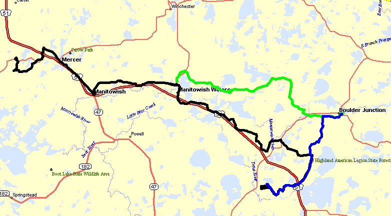
Start at the cabin (top left of the map - black line) Wednesday evening and head through Mercer, Manitowish, Manitowish Waters on the way to Boulder Junction. Somehow make a mistake at an intersection and make a right instead of a left (making that nice jump to the bottom center of the map). Fuel and bar stop (the bar is the gas station) at Popes then head back up towards Boulder Junction (via blue). Dinner at Boulder Junction then head back to the cabin via green / black.
|
|
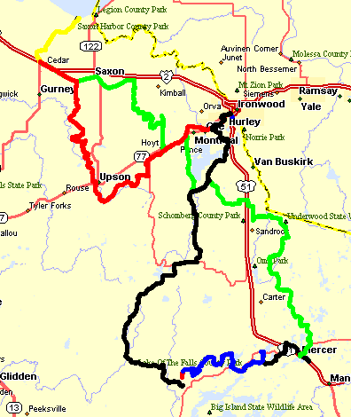
Thursday late morning we left the cabin (where blue and black meet in the bottom right of the map) and take black to Mercer (food & fuel). Green from Mercer and up to Cedar with a nice stop for some fun with a bump in the trail and then some pictures on trail 6A (the squiggly section of green track just North of Hoyt) which I consider to yet be the most scenic piece of trail. Fuel at Cedar and head up (and back) to Saxon Harber (look at Lake Superior). Unfortunately it was after sunset and had some light fog / haze so we couldn't see too much. Beak at the Frontier in Cedar. Red down to "Glidden" (at least that was the plan). Make a drastic wrong turn South of Upson (guess I won't be navigator next trip). Should have turned to the S/W but turned 'left' to the N/E. Skip Glidden and go to Hurley for dinner and fuel. Black out of Hurley and make our way back to the cabin. Black drops out and turns to red then blue (poor satellite coverage - tree canopy is heavy in the area). This 'chopped out' section is one of my favorite spots - narrow and straight with a nice canopy of tall trees.
|
|
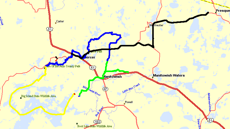
Day 3 The Plan - Go to town for food and fuel, back to the flowage (just to ride on a lake and see things we don't normally see on frozen water - pickup trucks for one), head towards Presque Isle for dinner then back to the cabin. What actually happened: Cabin (blue from West of Mercer to Mercer) > Mercer (brunch & gas) > back by cabin on yellow to the Turtle Flambeau Flowage > cross the flowage. Take a break after the flowage. Green line towards Manitowish and heading towards Manitowish Waters where we decided the trails were too poor - head back and up. Take a break for pictures (where green meets blue) & enjoy the scenery. Blue back through Mercer and to the cabin. Black line from the cabin to Presque Isle / Skyview Lodge (via on-road vehicle) for a nice dinner. If you are reading this page and it's daylight at the Skyview - click here to see a picture (updated every 30 seconds) looking out a window and down the trail (if it's nighttime there - don't just think your computer isn't working because the picture is black).
|